Gettin' Around
From the Denver Airport - Arriving at separate times but want to share a car? Consider the Boulder Super Shuttle! It leaves at ten minutes past every hour and travels from the Airport to central locations in Boulder - then have friends or family pick you up in town and share a car for the weekend. No reservation is needed from Denver International Airport and cost is negligible at just under $20 one-way. Laine and I have ridden it many times. Reservations are required when traveling from Boulder back to the Airport. http://www.bouldersupershuttle.com/supershuttle/boulder_supershuttle_DIA%20Denver.htm
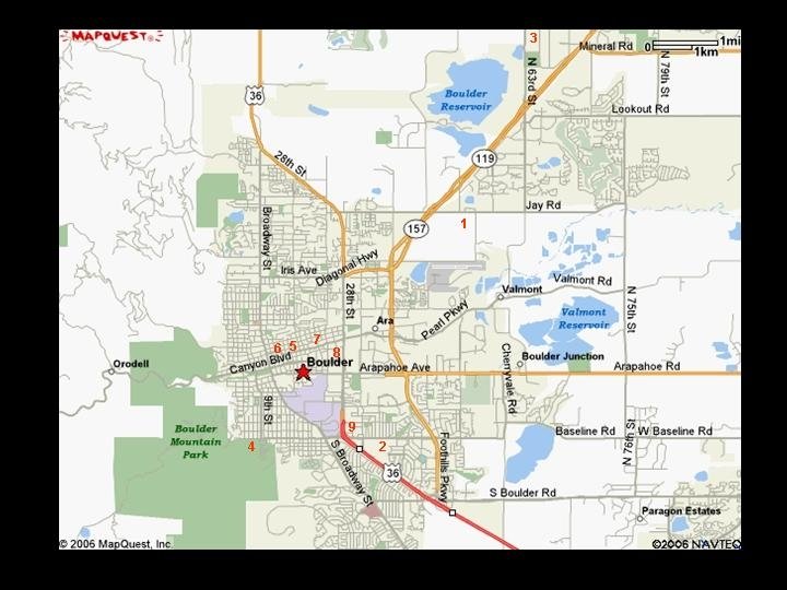
To help everyone hop around to the different events and activties, we thought this large-scale map would do the trick. (To enlarge the map, right-click on the map and choose "open link in new window," then maximize that window and reference the numbers below.)
1: Thursday Social
2: Rehearsal Dinner
3: Ryssbe Wedding Ceremony (top right corner)
4: Chautauqua Reception Hall
5: Pearl Street Mall
6: St. Julien
7: Boulder Marriot
8: MillennieumHarvest House
9: Boulder Inn
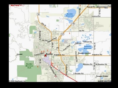
Directions and Driving Distances to the Main Events - the maps above and below show the common roads described in this section.
Getting to the Thursday BBQ:
- From Baseline (near the Boulder Inn) travel east approximately 1.8 miles to Foothills Parkway. Go left on Foothills Parkway and travel north...
- From Pearl Street (near the Millinium and other hotels) travel east to the intersection of Foothills Parkway. Go left on Foothills Parkway and travel north...
From either of these starting points, once you are at the intersection of Pearl and Foothills Parkway, travel 2.0 miles to Jay Rd. Go right on Jay till you come to 57th. Travel to 4091 N 57th.
Getting to the Ryssbe Church:
- From Baseline (near the Boulder Inn) travel east approximately 1.8 miles to Foothills Parkway. Go left on Foothills Parkway and travel north...
- From Pearl (near the Millinium and other hotels) travel east to the intersection of Foothills Parkway. Go left on Foothills Parkway and travel north...
- From either of these starting points, once you are at the intersection of Pearl and Foothills Parkway, travel north 4.2 miles to 63rd (Jay Rd is before 63rd and the IBM building is past 63rd). Take a left on 63rd (across westbound traffic) and travel another 4.5 miles. The church is small, white, and on the right-hand side. It sneaks up fast due to vegetation, but it is near the road and clearly visible.
Getting to the Chautauqua Dining/Reception Hall:
- Backtrack from the church on Foothills Parkway to it's intersection with Baseline. Go right on Baseline and travel west towards the foothills/mountains for approximately 1.8 miles. Continue straight across the intersection with 28th and travel approximately 1.2 miles slightly uphill until the tall-grass prairie reserve on the left. Take a left into Chautauqua and the reception/dining hall is an old white, wooden building in the top left corner of the rectangular drive.
We hope that this map is helpful for strictly in-town movement between food, lodging, etc. (To enlarge the map, follow the same directions as above)
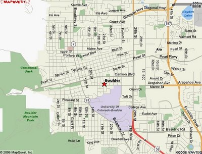
To help everyone hop around to the different events and activties, we thought this large-scale map would do the trick. (To enlarge the map, right-click on the map and choose "open link in new window," then maximize that window and reference the numbers below.)

1: Thursday Social
2: Rehearsal Dinner
3: Ryssbe Wedding Ceremony (top right corner)
4: Chautauqua Reception Hall
5: Pearl Street Mall
6: St. Julien
7: Boulder Marriot
8: MillennieumHarvest House
9: Boulder Inn
Directions and Driving Distances to the Main Events - the maps above and below show the common roads described in this section.
Getting to the Thursday BBQ:
- From Baseline (near the Boulder Inn) travel east approximately 1.8 miles to Foothills Parkway. Go left on Foothills Parkway and travel north...
- From Pearl Street (near the Millinium and other hotels) travel east to the intersection of Foothills Parkway. Go left on Foothills Parkway and travel north...
From either of these starting points, once you are at the intersection of Pearl and Foothills Parkway, travel 2.0 miles to Jay Rd. Go right on Jay till you come to 57th. Travel to 4091 N 57th.
Getting to the Ryssbe Church:
- From Baseline (near the Boulder Inn) travel east approximately 1.8 miles to Foothills Parkway. Go left on Foothills Parkway and travel north...
- From Pearl (near the Millinium and other hotels) travel east to the intersection of Foothills Parkway. Go left on Foothills Parkway and travel north...
- From either of these starting points, once you are at the intersection of Pearl and Foothills Parkway, travel north 4.2 miles to 63rd (Jay Rd is before 63rd and the IBM building is past 63rd). Take a left on 63rd (across westbound traffic) and travel another 4.5 miles. The church is small, white, and on the right-hand side. It sneaks up fast due to vegetation, but it is near the road and clearly visible.
Getting to the Chautauqua Dining/Reception Hall:
- Backtrack from the church on Foothills Parkway to it's intersection with Baseline. Go right on Baseline and travel west towards the foothills/mountains for approximately 1.8 miles. Continue straight across the intersection with 28th and travel approximately 1.2 miles slightly uphill until the tall-grass prairie reserve on the left. Take a left into Chautauqua and the reception/dining hall is an old white, wooden building in the top left corner of the rectangular drive.
We hope that this map is helpful for strictly in-town movement between food, lodging, etc. (To enlarge the map, follow the same directions as above)

posted by Durango Mama at 7:17 PM
![]()


0 Comments:
Post a Comment
<< Home